Summer heat is on the way from coast to coast, forecasters say, with high temperatures well into the 80s and 90s and even 100s in some areas.
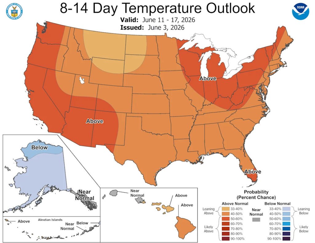
In fact, the national temperature outlook map for June 11-17 shows that above-normal temperatures are forecast for the entire lower 48 states.
A “period of record-breaking heat and increasing humidity is possible across much of the country into the middle part of the month,” said Washington Post meteorologist Ben Noll.
The heat wave will be the result of a strong ridge of high pressure that’s expected to set up over much of the country, the Climate Prediction Center said.

Above-normal temperatures are expected across the entire lower 48 states in mid-June 2026.
What is a ridge?
A ridge is a zone of higher atmospheric pressure where air sinks and warms, usually bringing clear, dry, and often hotter weather, the National Oceanic and Atmospheric Administration said.
“Typically a summertime occurrence, ridges are responsible for major heat waves. Any precipitation is usually shunted around the periphery of the high-pressure area,” NOAA said.
High pressure aloft causes the air to sink. This downward motion compresses and warms the air in the lower atmosphere while simultaneously trapping heat rising from the Earth’s surface, leading to heat waves.
The skies are also usually clear due to this downward motion of air.
East Coast to see heat risk impacts
NOAA’s Weather Prediction Center (WPC) said that the building ridge will promote above-average temperatures along the East Coast.
Warm nighttime temperatures could cause problems for those susceptible to extreme heat: “Warm low temperatures over much of the Mid-Atlantic could lead to moderate-to-major heat risk impacts for those without adequate cooling and hydration,” the WPC said.
“Combined with the June climatology and high sun angle, many areas are likely to see warmer-than-average temperatures during the middle part of June,” said Thomas Collow, a meteorologist with the National Weather Service’s extended prediction division, in an e-mail to USA TODAY on June 5. “Greater than half the lower 48 is also experiencing moderate drought conditions, helping to further increase temperatures over drier regions.”
Will all lower 48 states be warmer than average?
Collow said on June 5 that “while warmer-than-average temperatures are likely over most areas overall, a transient period of relatively cooler weather is possible across the western U.S. into the middle of next week as a front moves across the region, with this system potentially providing some heat relief to the central U.S. by the end of next week.”
However, he said that temperatures are forecast to quickly rebound across the western U.S., with significant warming across the Pacific Northwest, California, and into the Southwest.
How long is this warm pattern expected to last?
The longest duration of warmth is predicted to be across the western U.S., where ridging is forecast to become dominant into late June, Collow said.
“East of the Rockies, above-normal temperatures are likely to be more transient tied to frontal activity, but a sustained period of warmth is increasingly likely across portions of the eastern U.S. lasting through at least mid-June,” he said.
Heat safety basics
Check the weather: Your favorite weather app should have a wealth of information about UV index (for sunblock purposes), heat warnings and the feels-like temperature (more on why that’s important below.) Heat.gov has additional information about the forecast and heat risk.
Bring water: You’ll need multiple bottles of water per person if you’re spending extended time in the sun. (How many bottles? Read more here.)
Seek shade and air conditioning: Minimize your risk by staying cool and avoiding direct sun when you can.
Contributing: Joel Shannon, USA TODAY
Doyle Rice is a national correspondent for USA TODAY, with a focus on weather and climate.
This article originally appeared on USA TODAY: Weather forecast calls for coast-to-coast heat wave in mid-June
Source link